
Land and Environment
Integrated land, survey and environmental expertise enables compliant delivery, long term estate management and sustainable infrastructure development across complex sites and corridors.
Read more
Every good project starts with reliable information. Freedom's survey and geospatial team gives you certainty on the ground before you commit to design, programme or budget.
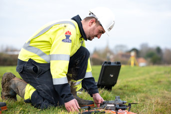
Large site, tight programme? Our drone teams can cover up to 100 hectares in a single flight, and surveys are often completed in a quarter of the time of traditional methods. That means less time on site, fewer people exposed to risk and measurable data your designers can use straight away.
Drone LiDAR can also capture ground levels beneath medium vegetation, without costly, disruptive ground clearance.
An unmapped service can derail a programme in seconds. Our PAS 128 utility surveys show you what is beneath the surface before the first dig, so your design, safety plan and programme are built on evidence, not assumptions.
Early survey data shows you levels, features, boundaries and buried utilities, so layouts, drainage and costs are based on reality. It's the right start for development, infrastructure and upgrade projects.
Refurbishment and upgrade projects depend on what is actually on site. We produce accurate floor plans, elevations, sections and 3D models, ready for BIM, so you design from what's really there.
How do you survey a 10km+ 33kV overhead line that crosses railways and major roads? From the air. Our aerial surveys capture the data your design team needs where physical access isn't possible, and can measure clearances, vegetation encroachment and asset condition, so you can plan maintenance with evidence, not guesswork
Aerial surveys identify defects, condition issues and thermal anomalies from above, with no scaffolding, no working at height and no site shutdown.
Open trial holes mean cones, delays and queues. We capture a colourised point cloud of each hole, so designers can inspect and measure features remotely.
The hole can be filled quickly, disruption stays low and the evidence is preserved.
Ground and structures move. Monitoring over the short or long term gives you early sight of change, so you can act on evidence rather than react to a problem.
We are a strategic partner for power and infrastructure, specialising in private networks and independent connections while supporting regulated electricity network delivery at scale. We provide an integrated, multidisciplinary service covering the full project lifecycle: strategy, design, approvals, construction, commissioning and long term asset management. As an Independent Connections Provider (ICP) we work on low, high and extra high voltage infrastructure, 11kV to 132kV and beyond. We reduce risk, accelerate delivery and support long term network resilience across complex environments.
Contact usIntegrated land, survey and environmental expertise enables compliant delivery, long term estate management and sustainable infrastructure development across complex sites and corridors.

Supporting early stage planning and complex delivery through feasibility, design assurance, project management and asset strategy. Our advisory services help clients make informed decisions that balance compliance, performance and long term value.
Dedicated regional teams supporting electricity Distribution Network Operators across inspection, maintenance, renewal and emergency response within regulated network environments.

Delivering high voltage infrastructure, including substations, major connections, overhead lines, cabling and private networks, supported by rigorous engineering standards and safety governance.

Freedom's High Voltage Services (HVS) provides specialist maintenance, diagnostics and asset support for some of the UK's most critical electricity infrastructure. Working across 132kV, 275kV and 400kV assets, we help asset owners maintain network reliability, maximise asset life and minimise operational risk

Developing and deploying innovative engineered solutions that improve safety, efficiency and constructability across high voltage power delivery and network infrastructure.
Have a question or want to discuss a project for Freedom? Complete our contact form and a member of our team will get back to you as soon as possible.
